Segmentize
export segmentize
export LinearSegments, GeodesicSegments
This function "segmentizes" or "densifies" a geometry by adding extra vertices to the geometry so that no segment is longer than a given distance. This is useful for plotting geometries with a limited number of vertices, or for ensuring that a geometry is not too "coarse" for a given application.
Info
We plan to add interpolated segmentization from DataInterpolations.jl in the future, which will be available to any vector of point-like objects.
For now, this function only works on 2D geometries. We will also support 3D geometries, as well as measure interpolation, in the future.Examples
import GeometryOps as GO, GeoInterface as GI
rectangle = GI.Wrappers.Polygon([[(0.0, 50.0), (7.071, 57.07), (0, 64.14), (-7.07, 57.07), (0.0, 50.0)]])
linear = GO.segmentize(rectangle; max_distance = 5)
collect(GI.getpoint(linear))
9-element Vector{Tuple{Float64, Float64}}:
(0.0, 50.0)
(3.5355, 53.535)
(7.071, 57.07)
(3.5355, 60.605000000000004)
(0.0, 64.14)
(-3.535, 60.605000000000004)
(-7.07, 57.07)
(-3.535, 53.535)
(0.0, 50.0)You can see that this geometry was segmentized correctly, and now has 8 vertices where it previously had only 4.
Now, we'll also segmentize this using the geodesic method, which is more accurate for lat/lon coordinates.
using Proj # required to activate the `Geodesic` method!
geodesic = GO.segmentize(GO.Geodesic(#=ellipsoid params here=#), rectangle; max_distance = 1000)
length(GI.getpoint(geodesic) |> collect)3585This has a lot of points! It's important to keep in mind that the max_distance is in meters, so this is a very fine-grained segmentation.
Now, let's see what they look like! To make this fair, we'll use approximately the same number of points for both.
using CairoMakie
linear = GO.segmentize(rectangle; max_distance = 0.01)
geodesic = GO.segmentize(GO.Geodesic(), rectangle; max_distance = 1000)
f, a, p = poly(collect(GI.getpoint(linear)); label = "Linear", axis = (; aspect = DataAspect()))
p2 = poly!(collect(GI.getpoint(geodesic)); label = "Geodesic")
axislegend(a; position = :lt)
f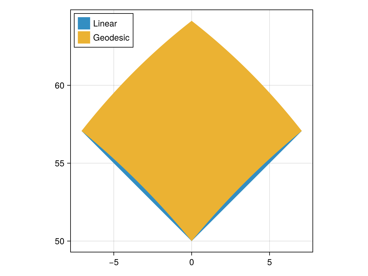
There are three methods available for segmentizing geometries at the moment, and you can invoke them by passing the relevant Manifold:
GeometryOpsCore.Planar Type
Planar()A planar manifold refers to the 2D Euclidean plane.
Z coordinates may be accepted but will not influence geometry calculations, which are done purely on 2D geometry. This is the standard "2.5D" model used by e.g. GEOS.
sourceGeometryOpsCore.Spherical Type
Spherical(; radius, oriented = false)A spherical manifold means that the geometry is on the 3-sphere (but is represented by 2-D longitude and latitude).
oriented selects how the interior of a polygon ring is interpreted:
oriented = false(the default): a ring's interior is the region it encloses — the smaller of the two regions it bounds — independent of winding direction. This matches how most of the ecosystem treats unoriented data by default (R'ss2/sf, spherely, BigQuery), and means shapefile-convention data (clockwise shells) is read the same way as counterclockwise data. No region larger than a hemisphere can be represented.oriented = true: polygon ring directions are known to be correct — exterior rings counterclockwise, interior rings clockwise — so the interior of the polygon is the region on the left of each ring's stored vertex order (the convention of S2'sS2Polygon::InitOriented). This makes regions larger than a hemisphere representable, e.g. "the sphere minus a small cap" as a clockwise ring.
Extended help
Note
The traditional definition of spherical coordinates in physics and mathematics, z-axis.
Here, we use the geographic definition of longitude and latitude, meaning that lon is longitude between -180 and 180, and lat is latitude between -90 (south pole) and 90 (north pole).
Note
With oriented = true, a ring may denote a region covering most of the sphere. Operations remain correct on such regions, but extent-based pruning degenerates (the region's bounding box is essentially the whole sphere), so spatial predicates against them fall back to slower paths.
Validity is manifold-dependent
A ring that is valid in lon/lat can be invalid on the sphere: two non-adjacent edges may cross when reinterpreted as great-circle arcs (a planar needle a few meters wide is enough — Natural Earth 110m Sudan is a real instance), and no planar validity tool can detect it. Prepared spherical predicates (GeometryOps.prepare) therefore validate against this class by default and throw an "edge i crosses edge j" error; the remedy is the GeometryOps.CrossingEdgeSplit correction, which splits each ring at its crossing points into separate loops (even-odd semantics).
GeometryOpsCore.Geodesic Type
Geodesic(; semimajor_axis, inv_flattening)A geodesic manifold means that the geometry is on a 3-dimensional ellipsoid, parameterized by semimajor_axis (inv_flattening (
Usually, this is only relevant for area and segmentization calculations. It becomes more relevant as one grows closer to the poles (or equator).
sourceSpherical interpolates along the great circle joining each pair of points, so it sits between Planar and Geodesic: it accounts for the curvature of the Earth, but treats it as a sphere rather than an ellipsoid. A spherical segmentization is not a refinement of the planar one — the great circle joining two points on the same parallel bows poleward of that parallel:
parallel = GI.LineString([(-50.0, 52.0), (50.0, 52.0)])
collect(GI.getpoint(GO.segmentize(GO.Spherical(), parallel; max_distance = 3_500_000)))
3-element Vector{Tuple{Float64, Float64}}:
(-50.0, 52.0)
(-7.0870149636743696e-15, 63.33416405648445)
(50.0, 52.0)The added midpoint sits at 63.3°N, over 11° north of the 52°N parallel that Planar would have interpolated along.
Benchmark
We benchmark our method against LibGEOS's GEOSDensify method, which is a similar method for densifying geometries.
using BenchmarkTools: BenchmarkGroup
using Chairmarks: @be
using Main: plot_trials
using CairoMakie

import GeometryOps as GO, GeoInterface as GI, LibGEOS as LG

segmentize_suite = BenchmarkGroup(["title:Segmentize", "subtitle:Segmentize a rectangle"])

rectangle = GI.Wrappers.Polygon([[(0.0, 50.0), (7.071, 57.07), (0.0, 64.14), (-7.07, 57.07), (0.0, 50.0)]])
lg_rectangle = GI.convert(LG, rectangle)
POLYGON ((0 50, 7.071 57.07, 0 64.14, -7.07 57.07, 0 50))# These are initial distances, which yield similar numbers of points
# in the final geometry.
init_lin = 0.01
init_geo = 900
# LibGEOS.jl doesn't offer this function, so we just wrap it ourselves!
function densify(obj::LG.Geometry, tol::Real, context::LG.GEOSContext = LG.get_context(obj))
result = LG.GEOSDensify_r(context, obj, tol)
if result == C_NULL
error("LibGEOS: Error in GEOSDensify")
end
LG.geomFromGEOS(result, context)
end
# now, we get to the actual benchmarking:
for scalefactor in exp10.(LinRange(log10(0.1), log10(10), 5))
lin_dist = init_lin * scalefactor
geo_dist = init_geo * scalefactor
npoints_linear = GI.npoint(GO.segmentize(rectangle; max_distance = lin_dist))
npoints_geodesic = GI.npoint(GO.segmentize(GO.Geodesic(), rectangle; max_distance = geo_dist))
npoints_libgeos = GI.npoint(densify(lg_rectangle, lin_dist))
segmentize_suite["Linear"][npoints_linear] = @be GO.segmentize($(GO.Planar()), $rectangle; max_distance = $lin_dist) seconds=1
segmentize_suite["Geodesic"][npoints_geodesic] = @be GO.segmentize($(GO.Geodesic()), $rectangle; max_distance = $geo_dist) seconds=1
segmentize_suite["LibGEOS"][npoints_libgeos] = @be densify($lg_rectangle, $lin_dist) seconds=1
end
plot_trials(segmentize_suite)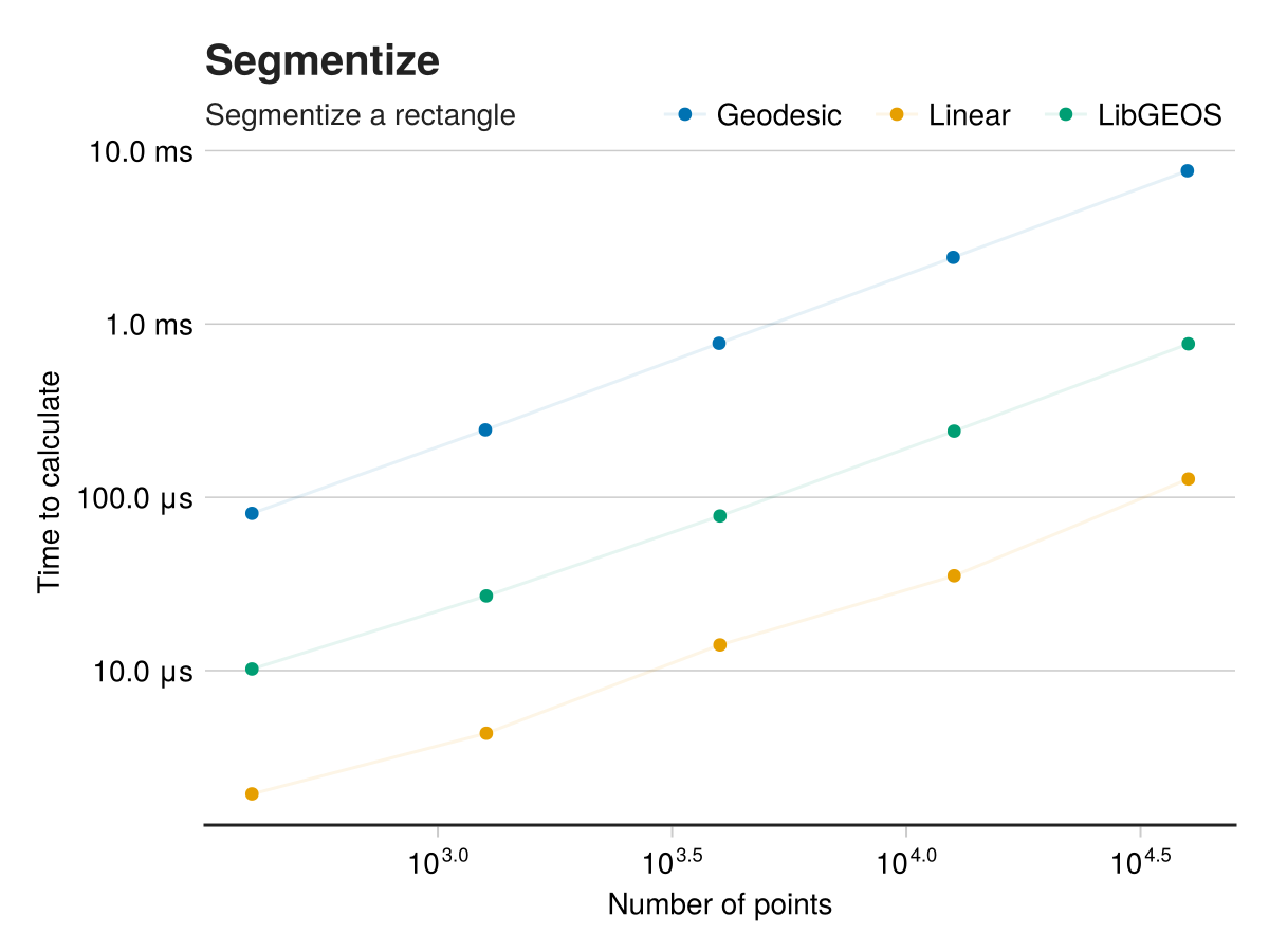
abstract type SegmentizeMethod end
"""
    LinearSegments(; max_distance::Real)

!!! warning
    This is deprecated - call `segmentize(Planar(), geom; max_distance)` instead.

A method for segmentizing geometries by adding extra vertices to the geometry so that no segment is longer than a given distance.

Here, `max_distance` is a purely nondimensional quantity and will apply in the input space.   This is to say, that if the polygon is
provided in lat/lon coordinates then the `max_distance` will be in degrees of arc.  If the polygon is provided in meters, then the
`max_distance` will be in meters.
"""
Base.@kwdef struct LinearSegments <: SegmentizeMethod
    max_distance::Float64
end

"""
    GeodesicSegments(; max_distance::Real, equatorial_radius::Real=6378137, flattening::Real=1/298.257223563)

!!! warning
    This is deprecated - call `segmentize(Geodesic(; semimajor_axis, inv_flattening), geom; max_distance)` instead.

A method for segmentizing geometries by adding extra vertices to the geometry so that no segment is longer than a given distance.
This method calculates the distance between points on the geodesic, and assumes input in lat/long coordinates.

!!! warning
    Any input geometries must be in lon/lat coordinates!  If not, the method may fail or error.

# Arguments
- `max_distance::Real`: The maximum distance, **in meters**, between vertices in the geometry.
- `equatorial_radius::Real=6378137`: The equatorial radius of the Earth, in meters.  Passed to `Proj.geod_geodesic`.
- `flattening::Real=1/298.257223563`: The flattening of the Earth, which is the ratio of the difference between the equatorial and polar radii to the equatorial radius.  Passed to `Proj.geod_geodesic`.

One can also omit the `equatorial_radius` and `flattening` keyword arguments, and pass a `geodesic` object directly to the eponymous keyword.

This method uses the Proj/GeographicLib API for geodesic calculations.
"""
struct GeodesicSegments{T} <: SegmentizeMethod
    geodesic::T# ::Proj.geod_geodesic
    max_distance::Float64
end
Add an error hint for GeodesicSegments if Proj is not loaded!
function _geodesic_segments_error_hinter(io, exc, argtypes, kwargs)
    if isnothing(Base.get_extension(GeometryOps, :GeometryOpsProjExt)) && exc.f == GeodesicSegments
        print(io, "\n\nThe `Geodesic` method requires the Proj.jl package to be explicitly loaded.\n")
        print(io, "You can do this by simply typing ")
        printstyled(io, "using Proj"; color = :cyan, bold = true)
        println(io, " in your REPL, \nor otherwise loading Proj.jl via using or import.")
    end
end
Implementation
"""
    segmentize([method = Planar()], geom; max_distance::Real, threaded)

Segmentize a geometry by adding extra vertices to the geometry so that no segment is longer than a given distance.
This is useful for plotting geometries with a limited number of vertices, or for ensuring that a geometry is not too "coarse" for a given application.

# Arguments
- `method::Manifold = Planar()`: The method to use for segmentizing the geometry.  At the moment, `Planar` (assumes a flat plane), `Spherical` (assumes geometry on a sphere and interpolates along great circles) and `Geodesic` (assumes geometry on the ellipsoidal Earth and uses Vincenty's formulae) are available.
- `geom`: The geometry to segmentize.  Must be a `LineString`, `LinearRing`, `Polygon`, `MultiPolygon`, or `GeometryCollection`, or some vector or table of those.
- `max_distance::Real`: The maximum distance between vertices in the geometry.
  For `Planar` manifolds, this is in the units of the geometry.  For `Spherical` and `Geodesic`, this is in the units of the manifold (the units of the radius of the sphere/ellipsoid).  By default this is meters.

`Spherical` and `Geodesic` both assume that the input geometry is in lon/lat coordinates, in degrees.

Returns a geometry of similar type to the input geometry, but resampled.
"""
function segmentize(geom; max_distance, threaded::Union{Bool, BoolsAsTypes} = False())
    return segmentize(Planar(), geom; max_distance, threaded = booltype(threaded))
end
allow three-arg method as well, just in case
segmentize(geom, max_distance::Real; threaded = False()) = segmentize(Planar(), geom, max_distance; threaded)
segmentize(method::Manifold, geom, max_distance::Real; threaded = False()) = segmentize(method, geom; max_distance, threaded)
generic implementation
function segmentize(method::Manifold, geom; max_distance, threaded::Union{Bool, BoolsAsTypes} = False())
    if max_distance <= 0
        throw(ArgumentError("`max_distance` should be positive and nonzero!  Found $(max_distance)."))
    end
    _segmentize_function(geom) = _segmentize(method, geom, GI.trait(geom); max_distance)
    return apply(_segmentize_function, TraitTarget(GI.LinearRingTrait(), GI.LineStringTrait()), geom; threaded)
end

function segmentize(method::SegmentizeMethod, geom; threaded::Union{Bool, BoolsAsTypes} = False())
    @warn "`segmentize(method::$(typeof(method)), geom) is deprecated; use `segmentize($(method isa LinearSegments ? "Planar()" : "Geodesic()"), geom; max_distance, threaded) instead!"  maxlog=3
    new_method = method isa LinearSegments ? Planar() : Geodesic()
    segmentize(new_method, geom; max_distance = method.max_distance, threaded)
end

_segmentize(method, geom) = _segmentize(method, geom, GI.trait(geom))
#=
This is a method which performs the common functionality for both linear and geodesic algorithms,
and calls out to the "kernel" function which we've defined per linesegment.
=#
function _segmentize(method::Union{Planar, Spherical}, geom, T::Union{GI.LineStringTrait, GI.LinearRingTrait}; max_distance)
    first_coord = GI.getpoint(geom, 1)
    x1, y1 = GI.x(first_coord), GI.y(first_coord)
    new_coords = NTuple{2, Float64}[]
    sizehint!(new_coords, GI.npoint(geom))
    push!(new_coords, (x1, y1))
    for coord in Iterators.drop(GI.getpoint(geom), 1)
        x2, y2 = GI.x(coord), GI.y(coord)
        _fill_linear_kernel!(method, new_coords, x1, y1, x2, y2; max_distance)
        x1, y1 = x2, y2
    end
    return rebuild(geom, new_coords)
end

function _fill_linear_kernel!(::Planar, new_coords::Vector, x1, y1, x2, y2; max_distance)
    dx, dy = x2 - x1, y2 - y1
    distance = hypot(dx, dy) # this is a more stable way to compute the Euclidean distance
    if distance > max_distance
        n_segments = ceil(Int, distance / max_distance)
        for i in 1:(n_segments - 1)
            t = i / n_segments
            push!(new_coords, (x1 + t * dx, y1 + t * dy))
        end
    end
End the line with the original coordinate, to avoid any multiplication errors.
    push!(new_coords, (x2, y2))
    return nothing
end
The spherical kernel walks the great circle joining the two points, instead of the straight line between them in lon/lat space. slerp gives us equally spaced points along that great circle, so we only have to decide how many of them to place.
max_distance is an arc length in units of method.radius: the angle subtended at the centre of the sphere, Ω, times the radius. So it's metres under the default (mean Earth) radius, and radians under Spherical(; radius = 1).
function _fill_linear_kernel!(method::Spherical, new_coords::Vector, x1, y1, x2, y2; max_distance)
    a = UnitSphereFromGeographic()((x1, y1))
    b = UnitSphereFromGeographic()((x2, y2))
    distance = spherical_distance(a, b) * method.radius
    if distance > max_distance
        n_segments = ceil(Int, distance / max_distance)
        for i in 1:(n_segments - 1)
            push!(new_coords, GeographicFromUnitSphere()(slerp(a, b, i / n_segments)))
        end
    end
End the line with the original coordinate, to avoid any multiplication errors.
    push!(new_coords, (x2, y2))
    return nothing
end
Note
The
_fill_linear_kerneldefinition forGeodesicSegmentsis in theGeometryOpsProjExtextension module, in thesegmentize.jlfile.
This page was generated using Literate.jl.