A round trip through a DGGS store
This tutorial shows how to persist a cell-indexed cube, reopen it lazily, and select only the stored cells needed for a region. It also compares the two cell-id encodings applicable to this regional axis. Complete levels can also use implicit encoding; see Store IO.
dggwrite and dggread are provided by the Zarr.jl extension, loaded by using Zarr.
import DiscreteGlobalGrids as DGG
import DimensionalData as DD
using Zarr
using DiscreteGlobalGridsVisualization: dggpoly, dggpoly!
using GLMakie, GeoMakie
GLMakie.activate!(inline = true)
A cube to write
The example uses two level-1 IGEO7 cells and their level-4 descendants as a small regional store. CellVector names the cells, CellLookup turns them into a one-level axis, and Cells makes that axis a cube dimension.
sys = DGG.IGeo7System()
roots = DGG.CellVector(DGG.levelgrid(sys, 1))[1:2]
cells = sort!(reduce(vcat, [collect(DGG.descendants(sys, c, 4)) for c in roots]))
lookup = DGG.CellLookup(DGG.CellVector(sys, 4, cells))
CellLookup(IGeo7System, level=4, ncells=629, 1 windows)The two layers share the cell axis. Their values encode axis positions, which makes the later selection checks easy to read.
n = length(cells)
elevation = Float32.(1:n)
slope = Float32.(0.5 .* (1:n))
cube = DD.DimStack((; elevation, slope), (DGG.Cells(lookup),))
┌ 629-element DimStack ┐
├──────────────────────┴────────────────────────────────────── dims ┐
↓ Cells CellLookup(IGeo7System, level=4, ncells=629, 1 windows)
├─────────────────────────────────────────────────────────── layers ┤
:elevation eltype: Float32 dims: Cells size: 629
:slope eltype: Float32 dims: Cells size: 629
└───────────────────────────────────────────────────────────────────┘Write the cube and read it back
dggwrite returns the path that dggread opens. chunks = 128 gives this small cube five chunks; :auto would place the whole example in one chunk.
path = DGG.dggwrite(joinpath(mktempdir(), "demo.zarr"), cube; chunks = 128)
store = DGG.dggread(path)
┌ 629-element DimStack ┐
├──────────────────────┴────────────────────────────────────────── dims ┐
↓ Cells ChunkedCellLookup(IGeo7System, level=4, ncells=629, ranges)
├─────────────────────────────────────────────────────────────── layers ┤
:elevation eltype: Float32 dims: Cells size: 629
:slope eltype: Float32 dims: Cells size: 629
├───────────────────────────────────────────────────────────────────────┴ metadata ┐
Dict{String, Any} with 5 entries:
"source" => "/tmp/jl_2JJiYl/demo.zarr"
"encoding" => "ranges"
"description" => StoreDescription(igeo7/z7int, level 4, RangesEncoding, coord…
"conventions" => ["zarr-conventions/dggs", "xdggs"]
"attrs" => Dict{String, Any}("dggs"=>Dict{String, Any}("coordinate"=>"c…
└──────────────────────────────────────────────────────────────────────────────────┘DD.metadata(store)["description"]StoreDescription(igeo7/z7int, level 4, RangesEncoding, coordinate "cell_id_ranges", 2 variables)dggread reconstructs the grid description from store attributes. The returned arrays stay lazy until a value is requested; collect makes an explicit in-memory comparison with the original cube:
axis = DD.lookup(store[:elevation], DGG.Cells)ChunkedCellLookup(IGeo7System, level=4, ncells=629, ranges)collect(axis) == cells, collect(parent(store[:elevation])) == elevation(true, true)Selecting a region out of a store
The axis is a ChunkedCellLookup. It supports the same selectors as a CellLookup and uses the chunk manifest to locate the required id data. Three selectors name a single cell:
At(cell)— the cell itself;Contains(cell)— the same cell;Contains((lon, lat))— the cell holding a point.
c = cells[300]
at = store[:elevation][DGG.Cells(DD.At(c))]
contains_cell = store[:elevation][DGG.Cells(DD.Contains(c))]
contains_point = store[:elevation][DGG.Cells(DD.Contains((67.5, 66.7)))]
at, contains_cell, contains_point
(300.0f0, 300.0f0, 300.0f0)Covering(target) selects every stored cell reached by the coverage of target. Here target is the extent of a level-2 ancestor, so the selection demonstrates the small spill beyond a region's exact boundary.
target = DGG.cell_extent(DGG.levelgrid(sys, 2), DGG.ancestor(sys, cells[300], 2))
region = store[:elevation][DGG.Cells(DGG.Covering(target))]
┌ 89-element DimArray{Float32, 1} elevation ┐
├───────────────────────────────────────────┴───────────────── dims ┐
↓ Cells CellLookup(IGeo7System, level=4, ncells=89, 20 windows)
├───────────────────────────────────────────────────────── metadata ┤
Dict{String, Any} with 1 entry:
"_ARRAY_DIMENSIONS" => Any["cell_ids"]
└───────────────────────────────────────────────────────────────────┘
Z7Cell("001000") 287.0
Z7Cell("001001") 288.0
Z7Cell("001002") 289.0
⋮
Z7Cell("001614") 592.0
Z7Cell("001615") 593.0
Z7Cell("001631") 603.0The selected result has a compressed in-memory CellLookup; the source remains a ChunkedCellLookup.
Which chunks a selection touches
A ChunkManifest describes the chunk grid in cell-axis positions. It records each chunk's bounds and maps an axis position to its chunk.
manifest = DGG.chunkmanifest(axis, 128)ChunkManifest(5 chunks of 128, 629 cells)DGG.nchunks(manifest), length(manifest)(5, 629)DGG.chunkbounds(manifest, 5)513:629The elevation values equal their positions, so selected values reveal which positions were fetched. chunkof maps each position to its chunk:
selected = Int.(collect(region))
sort(unique(DGG.chunkof.(Ref(manifest), selected)))
3-element Vector{Int64}:
3
4
5The figure shows stored cells coloured by chunk, the target as a dashed box, and the selected cells outlined. A compact spherical region can span several file chunks.
chunk = DGG.chunkof.(Ref(manifest), 1:n)
corners = [(target.X[1], target.Y[1]), (target.X[2], target.Y[1]),
           (target.X[2], target.Y[2]), (target.X[1], target.Y[2])]
box = [c1 .+ t .* (c2 .- c1) for (c1, c2) in zip(corners, circshift(corners, -1))
       for t in range(0, 1; length = 30)]

fig = Figure(size = (780, 470))
ax = GeoAxis(fig[1, 1]; dest = "+proj=laea +lon_0=44 +lat_0=64",
    limits = ((-16.0, 104.0), (45.0, 83.0)),
    xticks = 0:20:100, yticks = 50:10:80,
    title = "Stored cells by chunk; the cells Covering selects, outlined")
plt = dggpoly!(ax, cube[:elevation]; color = chunk,
    colormap = cgrad(:Set2, 5; categorical = true), colorrange = (0.5, 5.5))
lines!(ax, GeoMakie.coastlines(); color = ("#212529", 0.55), linewidth = 0.6)
dggpoly!(ax, region; color = :transparent, strokecolor = :black, strokewidth = 0.8)
lines!(ax, box; color = :black, linewidth = 2, linestyle = :dash)
Colorbar(fig[1, 2], plt; label = "chunk", ticks = 1:5)
fig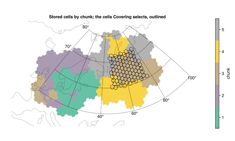
How to make that outline land in fewer chunks is the subject of Subzone layout.
Choosing how the cell ids are stored
An encoding describes how the store lays out cell ids. encoding = :auto chooses from the axis shape:
encoding | Stores | :auto picks it when |
|---|---|---|
:ranges | (n, 2) inclusive [start, stop] id intervals | the axis is sorted, unique and one level |
:dense | one id per cell | otherwise; also the interop choice for readers without interval support |
The Python package xdggs reads the dense layout only. target = :xdggs chooses it and checks the rest of what xdggs needs, so xr.open_dataset(path, engine="zarr").pipe(xdggs.decode) opens the result; see Writing a store for xdggs.
A ranges axis opens without reading coordinate data: length, chunk boundaries and selectors use rank/select arithmetic over its intervals. This store uses RangesEncoding, with one row per interval:
size(Zarr.zopen(path)["cell_id_ranges"], 2)91merge chooses what one interval may span:
merge | A run is | Rows | Read back correctly by |
|---|---|---|---|
:step (default) | ids adjacent as integers | more (91 here) | any reader that counts ids, grid-aware or not |
:rank | consecutive cells | fewest (1 here) | a rank-aware reader such as this package |
This axis is a single run of consecutive cells, so under :rank it is one row:
ranks = DGG.dggwrite(joinpath(mktempdir(), "ranks.zarr"), cube; chunks = 128,
                     merge = :rank)
size(Zarr.zopen(ranks)["cell_id_ranges"], 2)1Reading a store by URL
dggread also opens a public gs://, s3:// or https:// store in place. An s3:// URL additionally requires using AWSS3 to activate Zarr's S3 support. A selection then fetches the chunks it needs. For example:
pori = DGG.dggread("https://storage.googleapis.com/geo-assets/igeo7-zarr/pori_z7_r10.zarr")dggwrite writes to a local path or an open Zarr.ZGroup; publishing a remote store means uploading the directory it produced.
Out of core sweeps a kernel over a store chunk by chunk, starting from a store like the one written here.
This page was generated using Literate.jl.